Monte Llano night lights from space
Night Light of Monte Llano (Puerto Plata) from space (Dominican Republic) Src. Average luminocity for 10x10km area is 13.0702% and for 50x50km: 5.636%.
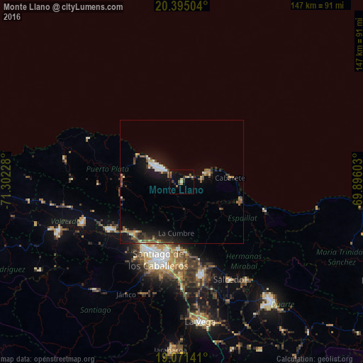
Analysis of Monte Llano night lights 2016
Square area 10x10 km:
 0%
0%90-99
0.83%80-89
2.89%70-79
1.65%60-69
2.89%50-59
1.24%40-49
2.27%30-39
3.1%20-29
1.65%10-19
3.31%0-9
80.17%Square area 50x50 km:
0.43%90-99
0.6%80-89
0.6%70-79
0.53%60-69
0.91%50-59
0.86%40-49
0.84%30-39
1.25%20-29
1.21%10-19
5.35%0-9
87.41%Clear (daylight) street map image can be seen on geolist.org.
Map coordinates:
20° 23' 42.1" North, 71° 18' 8.2" West
19° 44' 4.6" North, 70° 35' 56.9" West
19° 4' 17.1" North, 69° 53' 45.7" West
Some cities around Monte Llano sort by population:
• Puerto Plata
11.4 km =7.1 mi,  305°
305°
• Tamboril
27.7 km =17.2 mi,  182°
182°
• Río Grande
19.1 km =11.9 mi,  246°
246°
• Villa González
29.3 km =18.2 mi,  222°
222°
• Imbert
24.2 km =15 mi,  275°
275°
• Sosúa
8.5 km =5.3 mi,  76°
76°
• Veragua Arriba
32.5 km =20.2 mi,  121°
121°
• San Víctor Arriba
29.4 km =18.3 mi,  166°
166°
3496150 (p: 19,029)
Sources (retrieved 2019-11-25):
» Earth at Night: Flat Maps 2012, 2016