San Víctor Arriba night lights from space
Night Light of San Víctor Arriba (Espaillat) from space (Dominican Republic) Src. Average luminocity for 10x10km area is 15.626% and for 50x50km: 15.6494%.
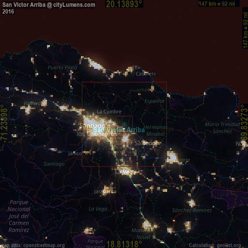
Analysis of San Víctor Arriba night lights 2016
Square area 10x10 km:
 0%
0%90-99
0%80-89
0.83%70-79
0%60-69
1.45%50-59
2.07%40-49
6.61%30-39
11.16%20-29
4.34%10-19
24.17%0-9
49.38%Square area 50x50 km:
1.72%90-99
2.02%80-89
1.49%70-79
1.75%60-69
3.07%50-59
2.26%40-49
3.38%30-39
4.08%20-29
4.28%10-19
9.67%0-9
66.27%Clear (daylight) street map image can be seen on geolist.org.
Map coordinates:
20° 8' 20.1" North, 71° 14' 20.3" West
19° 28' 38.7" North, 70° 32' 9.1" West
18° 48' 47.4" North, 69° 49' 57.8" West
Some cities around San Víctor Arriba sort by population:
• Santiago de los Caballeros
17.1 km =10.6 mi,  260°
260°
• Moca
9.4 km =5.8 mi,  173°
173°
• Salcedo
16.6 km =10.3 mi,  131°
131°
• Tamboril
7.9 km =4.9 mi,  276°
276°
• Salsipuedes
18.2 km =11.3 mi,  116°
116°
• Tenares
22.5 km =14 mi, 120°
• Licey al Medio
8.3 km =5.2 mi,  233°
233°
• Veragua Arriba
24.3 km =15.1 mi,  60°
60°
3492897 (p: 5,624)
Sources (retrieved 2019-11-25):
» Earth at Night: Flat Maps 2012, 2016