Laguna Salada night lights from space
Night Light of Laguna Salada (Valverde) from space (Dominican Republic) Src. Average luminocity for 10x10km area is 7.2727% and for 50x50km: 3.85%.
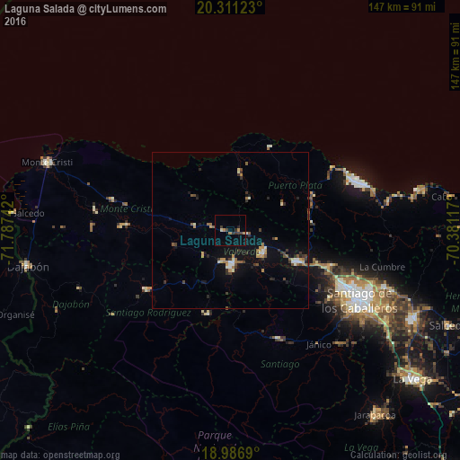
Analysis of Laguna Salada night lights 2016
Square area 10x10 km:
 0%
0%90-99
0%80-89
0.83%70-79
0.83%60-69
2.48%50-59
0%40-49
0.62%30-39
3.31%20-29
2.07%10-19
0.62%0-9
89.26%Square area 50x50 km:
0.27%90-99
0.49%80-89
0.23%70-79
0.61%60-69
0.58%50-59
0.46%40-49
0.5%30-39
0.86%20-29
0.67%10-19
2.04%0-9
93.29%Clear (daylight) street map image can be seen on geolist.org.
Map coordinates:
20° 18' 40.4" North, 71° 47' 14.7" West
19° 39' 1.5" North, 71° 5' 3.4" West
18° 59' 12.8" North, 70° 22' 52.2" West
Some cities around Laguna Salada sort by population:
• Mao
11 km =6.8 mi,  176°
176°
• Esperanza
12.7 km =7.9 mi,  125°
125°
• Villa Bisonó
23.9 km =14.9 mi,  113°
113°
• Río Grande
33.3 km =20.7 mi,  86°
86°
• Sabaneta
33.1 km =20.6 mi,  234°
234°
• Villa González
33.3 km =20.7 mi, 111°
• Imbert
29.1 km =18.1 mi,  66°
66°
• Monción
27.6 km =17.1 mi,  195°
195°
3502373 (p: 7,601)
Sources (retrieved 2019-11-25):
» Earth at Night: Flat Maps 2012, 2016