Dragør night lights from space
Night Light of Dragør (Capital Region) from space (Denmark) Src. Average luminocity for 10x10km area is 23.7318% and for 50x50km: 23.1178%.
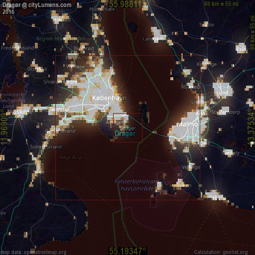
Analysis of Dragør night lights 2016
Square area 10x10 km:
 5.76%
5.76%90-99
5.39%80-89
0.75%70-79
2.01%60-69
1.38%50-59
1.25%40-49
5.01%30-39
3.63%20-29
9.52%10-19
13.91%0-9
51.38%Square area 50x50 km:
7.76%90-99
5.71%80-89
1.88%70-79
1.39%60-69
1.6%50-59
1.5%40-49
1.9%30-39
2.95%20-29
5.98%10-19
8.8%0-9
60.55%Clear (daylight) street map image can be seen on geolist.org.
Map coordinates:
55° 59' 17.2" North, 11° 58' 8.7" East
55° 35' 34.1" North, 12° 40' 20" East
55° 11' 36.5" North, 13° 22' 31.2" East
Some cities around Dragør sort by population:
• Copenhagen
11.4 km =7.1 mi,  324°
324°
• Frederiksberg
12.9 km =8 mi, 318°
• Hvidovre
14.4 km =8.9 mi,  299°
299°
• Vanløse
15.4 km =9.6 mi,  311°
311°
• Rødovre
16.8 km =10.4 mi, 305°
• Bunkeflostrand, SE
16.7 km =10.4 mi,  108°
108°
• Christianshavn
10.2 km =6.3 mi,  331°
331°
• Tårnby
6.1 km =3.8 mi, 312°
2622937 (p: 11,045)
Sources (retrieved 2019-11-25):
» Earth at Night: Flat Maps 2012, 2016