Christianshavn night lights from space
Night Light of Christianshavn (Capital Region) from space (Denmark) Src. Average luminocity for 10x10km area is 77.5646% and for 50x50km: 23.0015%.
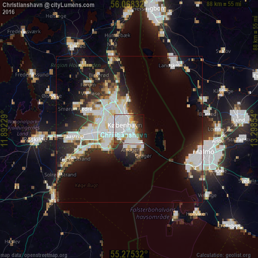
Analysis of Christianshavn night lights 2016
Square area 10x10 km:
 41.87%
90-99
20.33%80-89
3.47%70-79
3.59%60-69
3.47%50-59
3.23%40-49
4.19%30-39
3.71%20-29
8.61%10-19
5.86%0-9
1.67%Square area 50x50 km:
6.5%90-99
5.62%80-89
2.03%70-79
1.71%60-69
1.88%50-59
1.74%40-49
2.01%30-39
2.67%20-29
5.84%10-19
12.71%0-9
57.31%Clear (daylight) street map image can be seen on geolist.org.
Map coordinates:
56° 4' 6" North, 11° 53' 32.2" East
55° 40' 25.8" North, 12° 35' 43.5" East
55° 16' 31.2" North, 13° 17' 54.7" East
Some cities around Christianshavn sort by population:
• Copenhagen
1.9 km =1.2 mi,  277°
277°
• Frederiksberg
3.9 km =2.4 mi, 279°
• Hvidovre
7.9 km =4.9 mi,  256°
256°
• Charlottenlund
8.8 km =5.5 mi,  351°
351°
• Vanløse
6.9 km =4.3 mi, 279°
• Rødovre
8.9 km =5.5 mi,  274°
274°
• Dragør
10.2 km =6.3 mi,  151°
151°
• Tårnby
4.8 km =3 mi,  176°
176°
2623181 (p: 10,140)
Sources (retrieved 2019-11-25):
» Earth at Night: Flat Maps 2012, 2016