Zeuthen night lights from space
Night Light of Zeuthen (Brandenburg) from space (Germany) Src. Average luminocity for 10x10km area is 26.0644% and for 50x50km: 25.4519%.
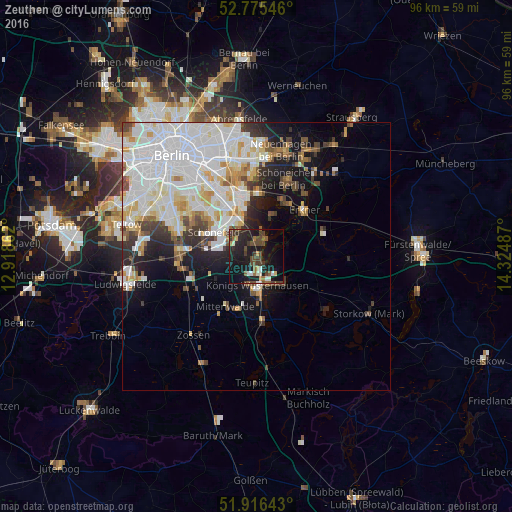
Analysis of Zeuthen night lights 2016
Square area 10x10 km:
 1.89%
1.89%90-99
2.9%80-89
0.76%70-79
1.64%60-69
2.9%50-59
4.67%40-49
10.1%30-39
6.06%20-29
8.46%10-19
35.48%0-9
25.13%Square area 50x50 km:
9.06%90-99
6.91%80-89
2.32%70-79
1.89%60-69
1.59%50-59
1.74%40-49
2.46%30-39
2.29%20-29
3.14%10-19
7.41%0-9
61.17%Clear (daylight) street map image can be seen on geolist.org.
Map coordinates:
52° 46' 31.7" North, 12° 55' 7" East
52° 20' 52.9" North, 13° 37' 18.3" East
51° 54' 59.1" North, 14° 19' 29.5" East
Some cities around Zeuthen sort by population:
• Königs Wusterhausen
5.2 km =3.2 mi,  171°
171°
• Altglienicke
9.1 km =5.7 mi,  320°
320°
• Schönefeld
9.2 km =5.7 mi,  299°
299°
• Bohnsdorf
6.1 km =3.8 mi,  327°
327°
• Schulzendorf
1.9 km =1.2 mi,  305°
305°
• Müggelheim
7.6 km =4.7 mi,  22°
22°
• Eichwalde
2.1 km =1.3 mi,  350°
350°
• Grünau
8.1 km =5 mi,  339°
339°
2804646 (p: 10,084)
Sources (retrieved 2019-11-25):
» Earth at Night: Flat Maps 2012, 2016