Schulzendorf night lights from space
Night Light of Schulzendorf (Brandenburg) from space (Germany) Src. Average luminocity for 10x10km area is 31.8245% and for 50x50km: 27.6685%.
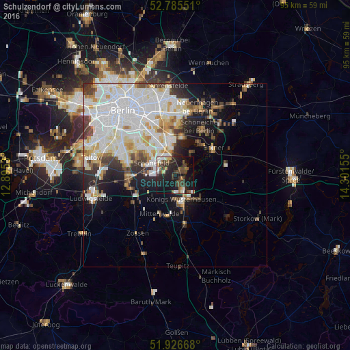
Analysis of Schulzendorf night lights 2016
Square area 10x10 km:
 4.04%
4.04%90-99
5.18%80-89
1.26%70-79
2.53%60-69
2.27%50-59
5.05%40-49
9.34%30-39
6.82%20-29
12.12%10-19
37.25%0-9
14.14%Square area 50x50 km:
9.6%90-99
7.5%80-89
2.56%70-79
2.1%60-69
1.79%50-59
1.93%40-49
2.89%30-39
2.74%20-29
3.52%10-19
7.77%0-9
57.61%Clear (daylight) street map image can be seen on geolist.org.
Map coordinates:
52° 47' 7.8" North, 12° 53' 43.1" East
52° 21' 29.4" North, 13° 35' 54.3" East
51° 55' 36" North, 14° 18' 5.6" East
Some cities around Schulzendorf sort by population:
• Königs Wusterhausen
6.7 km =4.2 mi,  159°
159°
• Altglienicke
7.3 km =4.5 mi,  324°
324°
• Schönefeld
7.3 km =4.5 mi,  298°
298°
• Bohnsdorf
4.4 km =2.7 mi,  337°
337°
• Zeuthen
1.9 km =1.2 mi,  125°
125°
• Müggelheim
7.4 km =4.6 mi,  36°
36°
• Eichwalde
1.6 km =1 mi,  52°
52°
• Grünau
6.6 km =4.1 mi,  349°
349°
2835787 (p: 7,452)
Sources (retrieved 2019-11-25):
» Earth at Night: Flat Maps 2012, 2016