Müggelheim night lights from space
Night Light of Müggelheim (Berlin) from space (Germany) Src. Average luminocity for 10x10km area is 18.1566% and for 50x50km: 25.9849%.
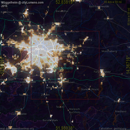
Analysis of Müggelheim night lights 2016
Square area 10x10 km:
 0.38%
0.38%90-99
2.02%80-89
0.38%70-79
1.26%60-69
1.14%50-59
3.28%40-49
7.2%30-39
4.67%20-29
9.6%10-19
20.58%0-9
49.49%Square area 50x50 km:
8.75%90-99
6.72%80-89
2.39%70-79
2.09%60-69
1.72%50-59
2.03%40-49
2.72%30-39
2.83%20-29
3.69%10-19
7.85%0-9
59.2%Clear (daylight) street map image can be seen on geolist.org.
Map coordinates:
52° 50' 17.5" North, 12° 57' 39.3" East
52° 24' 40.9" North, 13° 39' 50.5" East
51° 58' 49.4" North, 14° 22' 1.8" East
Some cities around Müggelheim sort by population:
• Berlin Köpenick
6.5 km =4 mi,  302°
302°
• Friedrichshagen
5.1 km =3.2 mi,  328°
328°
• Schöneiche
7.1 km =4.4 mi,  15°
15°
• Erkner
6.2 km =3.9 mi,  81°
81°
• Bohnsdorf
6.4 km =4 mi,  252°
252°
• Rahnsdorf
3.7 km =2.3 mi,  25°
25°
• Eichwalde
5.9 km =3.7 mi,  212°
212°
• Grünau
5.7 km =3.5 mi,  275°
275°
2868837 (p: 6,463)
Sources (retrieved 2019-11-25):
» Earth at Night: Flat Maps 2012, 2016