Grünau night lights from space
Night Light of Grünau (Berlin) from space (Germany) Src. Average luminocity for 10x10km area is 58.7323% and for 50x50km: 31.5253%.
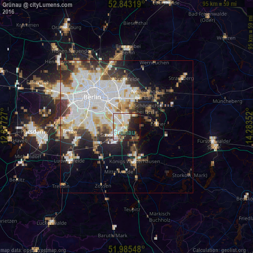
Analysis of Grünau night lights 2016
Square area 10x10 km:
 15.03%
90-99
19.7%80-89
6.94%70-79
5.68%60-69
2.53%50-59
5.05%40-49
5.3%30-39
5.43%20-29
13.51%10-19
16.04%0-9
4.8%Square area 50x50 km:
10.03%90-99
8.2%80-89
3.04%70-79
2.61%60-69
2.28%50-59
2.55%40-49
3.42%30-39
3.96%20-29
5.28%10-19
8.75%0-9
49.86%Clear (daylight) street map image can be seen on geolist.org.
Map coordinates:
52° 50' 35.5" North, 12° 52' 38.2" East
52° 24' 59.1" North, 13° 34' 49.4" East
51° 59' 7.7" North, 14° 17' 0.7" East
Some cities around Grünau sort by population:
• Köpenick
3.3 km =2.1 mi,  353°
353°
• Berlin Köpenick
2.9 km =1.8 mi,  2°
2°
• Altglienicke
3.1 km =1.9 mi,  259°
259°
• Friedrichshagen
4.8 km =3 mi,  38°
38°
• Adlershof
3 km =1.9 mi,  314°
314°
• Schönefeld
6 km =3.7 mi,  239°
239°
• Bohnsdorf
2.5 km =1.6 mi,  190°
190°
• Müggelheim
5.7 km =3.5 mi,  95°
95°
2914477 (p: 5,408)
Sources (retrieved 2019-11-25):
» Earth at Night: Flat Maps 2012, 2016