Bohnsdorf night lights from space
Night Light of Bohnsdorf (Berlin) from space (Germany) Src. Average luminocity for 10x10km area is 53.0202% and for 50x50km: 30.9164%.
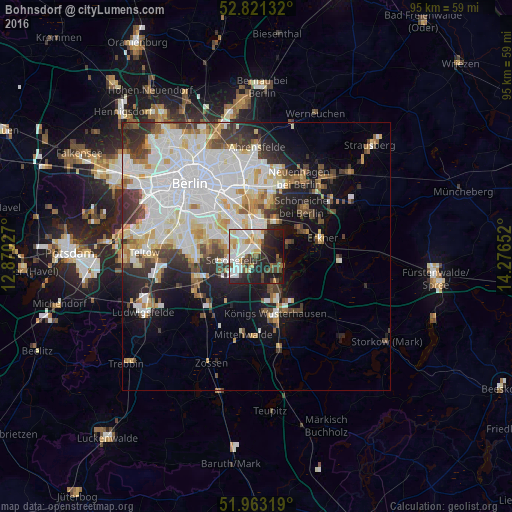
Analysis of Bohnsdorf night lights 2016
Square area 10x10 km:
 12.5%
12.5%90-99
15.91%80-89
5.05%70-79
5.18%60-69
2.9%50-59
4.04%40-49
7.32%30-39
6.06%20-29
17.93%10-19
20.96%0-9
2.15%Square area 50x50 km:
10.05%90-99
8.16%80-89
2.97%70-79
2.56%60-69
2.2%50-59
2.37%40-49
3.26%30-39
3.76%20-29
4.72%10-19
8.43%0-9
51.53%Clear (daylight) street map image can be seen on geolist.org.
Map coordinates:
52° 49' 16.8" North, 12° 52' 13" East
52° 23' 39.6" North, 13° 34' 24.2" East
51° 57' 47.5" North, 14° 16' 35.5" East
Some cities around Bohnsdorf sort by population:
• Köpenick
5.7 km =3.5 mi,  0°
0°
• Berlin Köpenick
5.4 km =3.4 mi,  6°
6°
• Altglienicke
3.2 km =2 mi,  306°
306°
• Adlershof
4.9 km =3 mi,  339°
339°
• Schönefeld
4.8 km =3 mi,  262°
262°
• Schulzendorf
4.4 km =2.7 mi,  157°
157°
• Eichwalde
4.3 km =2.7 mi,  136°
136°
• Grünau
2.5 km =1.6 mi, 10°
2946887 (p: 10,805)
Sources (retrieved 2019-11-25):
» Earth at Night: Flat Maps 2012, 2016