Schönefeld night lights from space
Night Light of Schönefeld (Brandenburg) from space (Germany) Src. Average luminocity for 10x10km area is 62.673% and for 50x50km: 32.7324%.
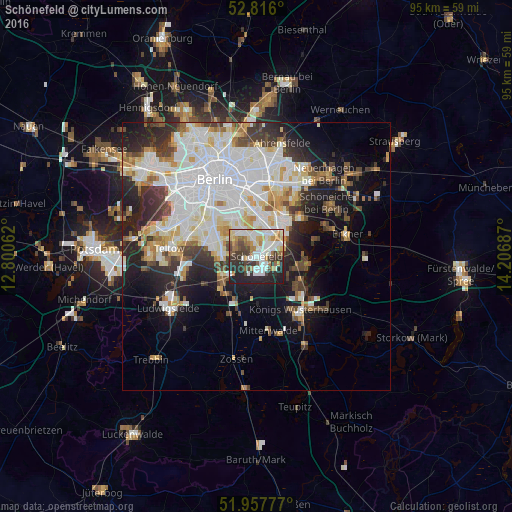
Analysis of Schönefeld night lights 2016
Square area 10x10 km:
 16.67%
90-99
17.3%80-89
6.94%70-79
5.56%60-69
6.69%50-59
5.68%40-49
6.19%30-39
10.86%20-29
16.29%10-19
7.83%0-9
0%Square area 50x50 km:
10.21%90-99
8.53%80-89
3.2%70-79
2.73%60-69
2.55%50-59
2.48%40-49
3.32%30-39
3.77%20-29
6.44%10-19
10.19%0-9
46.58%Clear (daylight) street map image can be seen on geolist.org.
Map coordinates:
52° 48' 57.6" North, 12° 48' 2.2" East
52° 23' 20.3" North, 13° 30' 13.5" East
51° 57' 28" North, 14° 12' 24.7" East
Some cities around Schönefeld sort by population:
• Rudow
4.1 km =2.5 mi,  342°
342°
• Buckow
5.6 km =3.5 mi,  328°
328°
• Gropiusstadt
4.7 km =2.9 mi, 327°
• Altglienicke
3.3 km =2.1 mi,  41°
41°
• Johannisthal
6.4 km =4 mi,  1°
1°
• Adlershof
6 km =3.7 mi,  30°
30°
• Bohnsdorf
4.8 km =3 mi,  82°
82°
• Grünau
6 km =3.7 mi,  59°
59°
2836761 (p: 12,015)
Sources (retrieved 2019-11-25):
» Earth at Night: Flat Maps 2012, 2016