Willstätt night lights from space
Night Light of Willstätt (Baden-Württemberg) from space (Germany) Src. Average luminocity for 10x10km area is 11.9182% and for 50x50km: 19.6614%.
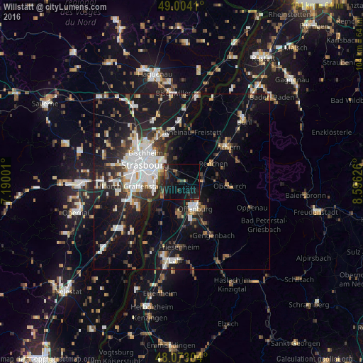
Analysis of Willstätt night lights 2016
Square area 10x10 km:
 0%
0%90-99
0%80-89
0.3%70-79
0.3%60-69
1.04%50-59
1.93%40-49
2.98%30-39
3.13%20-29
5.95%10-19
24.11%0-9
60.27%Square area 50x50 km:
4.33%90-99
3.83%80-89
1.43%70-79
1.44%60-69
1.65%50-59
1.89%40-49
2.19%30-39
3.26%20-29
5.13%10-19
16.79%0-9
58.06%Clear (daylight) street map image can be seen on geolist.org.
Map coordinates:
49° 0' 14.8" North, 7° 11' 24" East
48° 32' 26.6" North, 7° 53' 35.3" East
48° 4' 22.9" North, 8° 35' 46.5" East
Some cities around Willstätt sort by population:
• Strasbourg, FR
11.9 km =7.4 mi,  293°
293°
• Offenburg
8.4 km =5.2 mi,  152°
152°
• Kehl
6.8 km =4.2 mi,  302°
302°
• Schiltigheim, FR
12.9 km =8 mi,  305°
305°
• Illkirch-Graffenstaden, FR
13.2 km =8.2 mi,  264°
264°
• Schutterwald
10.1 km =6.3 mi,  184°
184°
• Renchen
10.3 km =6.4 mi,  58°
58°
• Haslach
12.3 km =7.6 mi,  77°
77°
2808493 (p: 9,061)
Sources (retrieved 2019-11-25):
» Earth at Night: Flat Maps 2012, 2016