Wiesloch night lights from space
Night Light of Wiesloch (Baden-Württemberg) from space (Germany) Src. Average luminocity for 10x10km area is 30.1832% and for 50x50km: 20.2443%.
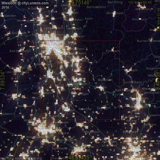

Analysis of Wiesloch night lights 2016
Square area 10x10 km:
 4.55%
4.55%90-99
4.55%80-89
1.74%70-79
2.41%60-69
6.28%50-59
1.74%40-49
4.41%30-39
3.07%20-29
22.33%10-19
24.47%0-9
24.47%Square area 50x50 km:
3.66%90-99
4.04%80-89
1.78%70-79
1.54%60-69
2.18%50-59
2.3%40-49
2.27%30-39
2.88%20-29
7.07%10-19
18.12%0-9
54.15%Clear (daylight) street map image can be seen on geolist.org.
Map coordinates:
49° 45' 5.3" North, 7° 59' 43.2" East
49° 17' 42.1" North, 8° 41' 54.5" East
48° 50' 3.7" North, 9° 24' 5.7" East
Some cities around Wiesloch sort by population:
• Leimen
5.9 km =3.7 mi,  352°
352°
• Walldorf
4.3 km =2.7 mi,  287°
287°
• Sandhausen
6 km =3.7 mi,  331°
331°
• Sankt Leon-Rot
6.7 km =4.2 mi,  240°
240°
• Nußloch
3.2 km =2 mi,  356°
356°
• Dielheim
3.1 km =1.9 mi,  112°
112°
• Mühlhausen
5.6 km =3.5 mi,  158°
158°
• Rauenberg
2.9 km =1.8 mi,  172°
172°
2809138 (p: 25,630)
Sources (retrieved 2019-11-25):
» Earth at Night: Flat Maps 2012, 2016