Rauenberg night lights from space
Night Light of Rauenberg (Baden-Württemberg) from space (Germany) Src. Average luminocity for 10x10km area is 28.6471% and for 50x50km: 19.2146%.
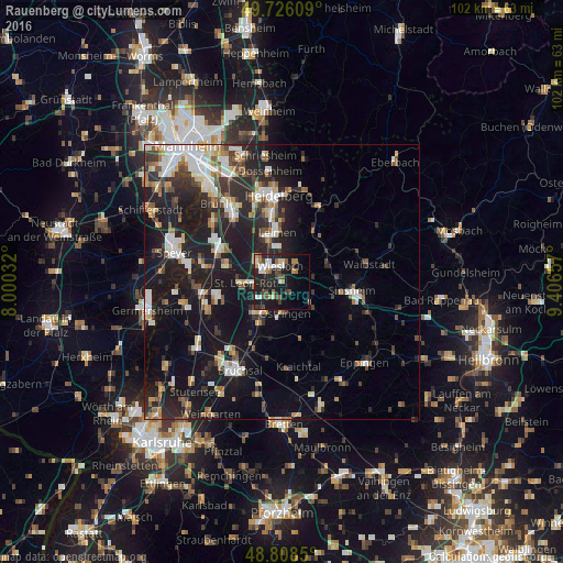
Analysis of Rauenberg night lights 2016
Square area 10x10 km:
 4.41%
4.41%90-99
4.68%80-89
2.01%70-79
2.14%60-69
5.08%50-59
2.67%40-49
5.48%30-39
3.34%20-29
13.9%10-19
25%0-9
31.28%Square area 50x50 km:
3%90-99
3.54%80-89
1.75%70-79
1.62%60-69
2.15%50-59
2.28%40-49
2.25%30-39
2.78%20-29
7.3%10-19
18.43%0-9
54.91%Clear (daylight) street map image can be seen on geolist.org.
Map coordinates:
49° 43' 33.9" North, 8° 0' 1.2" East
49° 16' 9.9" North, 8° 42' 12.4" East
48° 48' 30.6" North, 9° 24' 23.7" East
Some cities around Rauenberg sort by population:
• Wiesloch
2.9 km =1.8 mi,  352°
352°
• Walldorf
6 km =3.7 mi,  312°
312°
• Östringen
5.6 km =3.5 mi,  173°
173°
• Sankt Leon-Rot
6.2 km =3.9 mi,  266°
266°
• Nußloch
6.1 km =3.8 mi, 354°
• Dielheim
3 km =1.9 mi,  56°
56°
• Mühlhausen
2.9 km =1.8 mi,  143°
143°
• Kronau
7.4 km =4.6 mi,  225°
225°
2850056 (p: 7,411)
Sources (retrieved 2019-11-25):
» Earth at Night: Flat Maps 2012, 2016