Sankt Leon-Rot night lights from space
Night Light of Sankt Leon-Rot (Baden-Württemberg) from space (Germany) Src. Average luminocity for 10x10km area is 31.7821% and for 50x50km: 20.7638%.
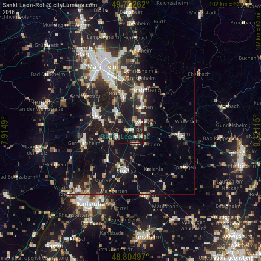
Analysis of Sankt Leon-Rot night lights 2016
Square area 10x10 km:
 4.55%
4.55%90-99
5.08%80-89
3.34%70-79
3.07%60-69
3.07%50-59
3.07%40-49
4.55%30-39
2.54%20-29
13.37%10-19
50.4%0-9
6.95%Square area 50x50 km:
3.17%90-99
3.72%80-89
1.77%70-79
1.77%60-69
2.35%50-59
2.42%40-49
2.67%30-39
2.91%20-29
7.92%10-19
20.45%0-9
50.85%Clear (daylight) street map image can be seen on geolist.org.
Map coordinates:
49° 43' 21.4" North, 7° 54' 53.6" East
49° 15' 57.3" North, 8° 37' 4.9" East
48° 48' 17.9" North, 9° 19' 16.1" East
Some cities around Sankt Leon-Rot sort by population:
• Wiesloch
6.7 km =4.2 mi,  60°
60°
• Hockenheim
8 km =5 mi,  323°
323°
• Waghäusel
7.9 km =4.9 mi,  256°
256°
• Walldorf
4.8 km =3 mi,  21°
21°
• Mühlhausen
8.1 km =5 mi,  103°
103°
• Rauenberg
6.2 km =3.9 mi,  86°
86°
• Reilingen
5.3 km =3.3 mi,  312°
312°
• Kronau
4.9 km =3 mi,  168°
168°
3272456 (p: 12,192)
Sources (retrieved 2019-11-25):
» Earth at Night: Flat Maps 2012, 2016