Nußloch night lights from space
Night Light of Nußloch (Baden-Württemberg) from space (Germany) Src. Average luminocity for 10x10km area is 34.8516% and for 50x50km: 21.6789%.
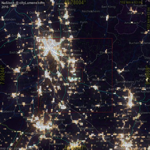
Analysis of Nußloch night lights 2016
Square area 10x10 km:
 6.02%
6.02%90-99
7.22%80-89
1.87%70-79
2.67%60-69
6.02%50-59
3.34%40-49
3.21%30-39
4.01%20-29
23.4%10-19
22.33%0-9
19.92%Square area 50x50 km:
4.4%90-99
4.7%80-89
1.85%70-79
1.65%60-69
2.17%50-59
2.28%40-49
2.38%30-39
3.13%20-29
7.37%10-19
16.96%0-9
53.12%Clear (daylight) street map image can be seen on geolist.org.
Map coordinates:
49° 46' 48.1" North, 7° 59' 32.8" East
49° 19' 26" North, 8° 41' 44" East
48° 51' 48.5" North, 9° 23' 55.3" East
Some cities around Nußloch sort by population:
• Leimen
2.7 km =1.7 mi,  347°
347°
• Wiesloch
3.2 km =2 mi,  176°
176°
• Walldorf
4.3 km =2.7 mi,  243°
243°
• Sandhausen
3.4 km =2.1 mi,  308°
308°
• Sankt Leon-Rot
8.6 km =5.3 mi,  221°
221°
• Dielheim
5.4 km =3.4 mi,  145°
145°
• Rauenberg
6.1 km =3.8 mi,  174°
174°
• Bammental
7.1 km =4.4 mi,  59°
59°
2861579 (p: 10,815)
Sources (retrieved 2019-11-25):
» Earth at Night: Flat Maps 2012, 2016