Walldorf night lights from space
Night Light of Walldorf (Baden-Württemberg) from space (Germany) Src. Average luminocity for 10x10km area is 36.5481% and for 50x50km: 21.6503%.
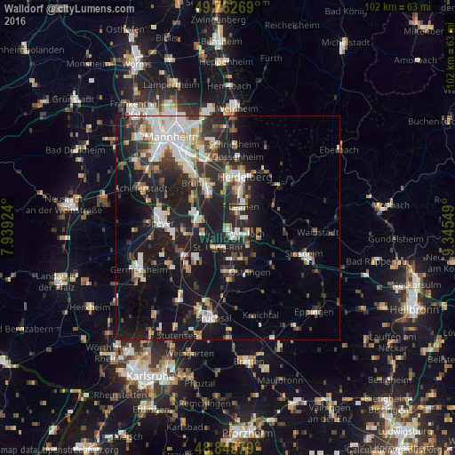
Analysis of Walldorf night lights 2016
Square area 10x10 km:
 5.61%
5.61%90-99
6.95%80-89
3.61%70-79
2.54%60-69
4.68%50-59
2.14%40-49
4.28%30-39
2.94%20-29
23.93%10-19
43.18%0-9
0.13%Square area 50x50 km:
4%90-99
4.37%80-89
1.79%70-79
1.61%60-69
2.22%50-59
2.31%40-49
2.55%30-39
3.12%20-29
7.6%10-19
19.71%0-9
50.71%Clear (daylight) street map image can be seen on geolist.org.
Map coordinates:
49° 45' 45.7" North, 7° 56' 21.3" East
49° 18' 22.9" North, 8° 38' 32.5" East
48° 50' 44.8" North, 9° 20' 43.8" East
Some cities around Walldorf sort by population:
• Leimen
5.6 km =3.5 mi,  35°
35°
• Wiesloch
4.3 km =2.7 mi,  107°
107°
• Hockenheim
6.8 km =4.2 mi,  286°
286°
• Sandhausen
4.2 km =2.6 mi,  16°
16°
• Sankt Leon-Rot
4.8 km =3 mi,  201°
201°
• Nußloch
4.3 km =2.7 mi,  63°
63°
• Rauenberg
6 km =3.7 mi,  132°
132°
• Reilingen
5.7 km =3.5 mi,  261°
261°
2814670 (p: 14,842)
Sources (retrieved 2019-11-25):
» Earth at Night: Flat Maps 2012, 2016