Mühlhausen night lights from space
Night Light of Mühlhausen (Baden-Württemberg) from space (Germany) Src. Average luminocity for 10x10km area is 17.4893% and for 50x50km: 17.7597%.
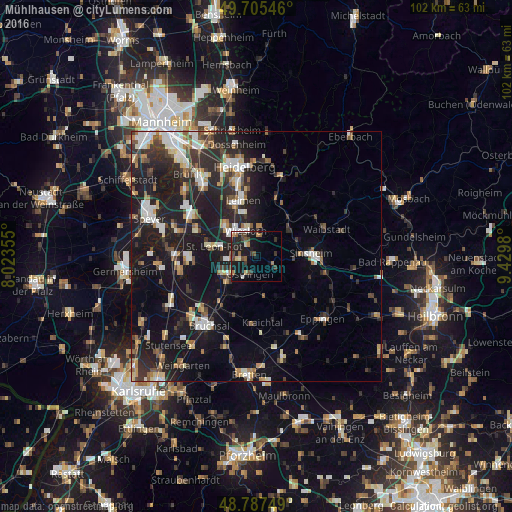
Analysis of Mühlhausen night lights 2016
Square area 10x10 km:
 1.07%
1.07%90-99
2.01%80-89
1.6%70-79
0.94%60-69
3.07%50-59
2.14%40-49
4.55%30-39
3.74%20-29
7.09%10-19
20.99%0-9
52.81%Square area 50x50 km:
2.53%90-99
2.96%80-89
1.73%70-79
1.52%60-69
1.96%50-59
2.18%40-49
2.27%30-39
2.72%20-29
7.01%10-19
17.67%0-9
57.45%Clear (daylight) street map image can be seen on geolist.org.
Map coordinates:
49° 42' 19.7" North, 8° 1' 24.8" East
49° 14' 55" North, 8° 43' 36" East
48° 47' 15" North, 9° 25' 47.3" East
Some cities around Mühlhausen sort by population:
• Wiesloch
5.6 km =3.5 mi,  338°
338°
• Walldorf
8.9 km =5.5 mi,  316°
316°
• Östringen
3.5 km =2.2 mi,  198°
198°
• Sankt Leon-Rot
8.1 km =5 mi,  283°
283°
• Nußloch
8.7 km =5.4 mi, 344°
• Dielheim
4 km =2.5 mi,  11°
11°
• Rauenberg
2.9 km =1.8 mi, 323°
• Kronau
7.5 km =4.7 mi,  247°
247°
2868004 (p: 8,176)
Sources (retrieved 2019-11-25):
» Earth at Night: Flat Maps 2012, 2016