Wesseling night lights from space
Night Light of Wesseling (North Rhine-Westphalia) from space (Germany) Src. Average luminocity for 10x10km area is 57.549% and for 50x50km: 30.7459%.
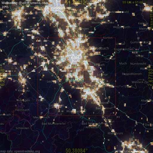

Analysis of Wesseling night lights 2016
Square area 10x10 km:
 13.03%
90-99
10.78%80-89
5.74%70-79
2.24%60-69
8.26%50-59
8.96%40-49
17.09%30-39
14.29%20-29
17.93%10-19
1.68%0-9
0%Square area 50x50 km:
5.82%90-99
6.42%80-89
2.93%70-79
2.89%60-69
4.34%50-59
4.07%40-49
4.02%30-39
5.56%20-29
8.13%10-19
15.63%0-9
40.19%Clear (daylight) street map image can be seen on geolist.org.
Map coordinates:
51° 16' 8.8" North, 6° 16' 17.7" East
50° 49' 37.5" North, 6° 58' 28.9" East
50° 22' 51" North, 7° 40' 40.2" East
Some cities around Wesseling sort by population:
• Hürth
9 km =5.6 mi,  302°
302°
• Bornheim
7.2 km =4.5 mi,  170°
170°
• Brühl
4.9 km =3 mi,  272°
272°
• Niederkassel
4.6 km =2.9 mi,  106°
106°
• Porz am Rhein
8.8 km =5.5 mi,  41°
41°
• Poll
9.6 km =6 mi,  6°
6°
• Bayenthal
9.5 km =5.9 mi,  357°
357°
• Wahn-Heide
9.9 km =6.2 mi,  69°
69°
2810612 (p: 35,665)
Sources (retrieved 2019-11-25):
» Earth at Night: Flat Maps 2012, 2016