Wahn-Heide night lights from space
Night Light of Wahn-Heide (North Rhine-Westphalia) from space (Germany) Src. Average luminocity for 10x10km area is 51.9846% and for 50x50km: 29.0296%.
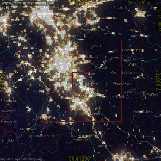
Analysis of Wahn-Heide night lights 2016
Square area 10x10 km:
 12.18%
90-99
11.48%80-89
3.64%70-79
4.2%60-69
6.86%50-59
4.48%40-49
3.78%30-39
17.65%20-29
26.05%10-19
8.68%0-9
0.98%Square area 50x50 km:
5.61%90-99
6.06%80-89
2.79%70-79
2.85%60-69
4.17%50-59
4.12%40-49
3.96%30-39
5.93%20-29
7.69%10-19
11.32%0-9
45.51%Clear (daylight) street map image can be seen on geolist.org.
Map coordinates:
51° 18' 2.3" North, 6° 24' 12.6" East
50° 51' 32.1" North, 7° 6' 23.8" East
50° 24' 46.7" North, 7° 48' 35.1" East
Some cities around Wahn-Heide sort by population:
• Troisdorf
6.3 km =3.9 mi,  151°
151°
• Niederkassel
6.9 km =4.3 mi,  224°
224°
• Lohmar
7.9 km =4.9 mi,  106°
106°
• Rösrath
6.7 km =4.2 mi,  52°
52°
• Porz am Rhein
4.6 km =2.9 mi,  312°
312°
• Ostheim
9.2 km =5.7 mi,  331°
331°
• Rath
7.3 km =4.5 mi,  352°
352°
• Eil
4.3 km =2.7 mi, 333°
2815375 (p: 7,692)
Sources (retrieved 2019-11-25):
» Earth at Night: Flat Maps 2012, 2016