Porz am Rhein night lights from space
Night Light of Porz am Rhein (North Rhine-Westphalia) from space (Germany) Src. Average luminocity for 10x10km area is 62.7059% and for 50x50km: 29.9561%.
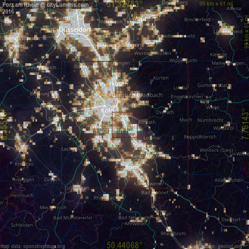
Analysis of Porz am Rhein night lights 2016
Square area 10x10 km:
 14.01%
90-99
12.04%80-89
5.46%70-79
5.6%60-69
15.97%50-59
12.32%40-49
7.56%30-39
15.55%20-29
10.92%10-19
0.56%0-9
0%Square area 50x50 km:
5.76%90-99
6.12%80-89
2.84%70-79
2.98%60-69
4.1%50-59
4.27%40-49
4.24%30-39
6.32%20-29
8.11%10-19
12.25%0-9
43.01%Clear (daylight) street map image can be seen on geolist.org.
Map coordinates:
51° 19' 40.2" North, 6° 21' 18.6" East
50° 53' 10.9" North, 7° 3' 29.9" East
50° 26' 26.4" North, 7° 45' 41.1" East
Some cities around Porz am Rhein sort by population:
• Humboldtkolonie
6.7 km =4.2 mi,  318°
318°
• Höhenberg
5.3 km =3.3 mi,  347°
347°
• Ostheim
5.1 km =3.2 mi, 348°
• Poll
5.6 km =3.5 mi,  301°
301°
• Rath
4.8 km =3 mi,  30°
30°
• Eil
1.7 km =1.1 mi,  61°
61°
• Bayenthal
7 km =4.3 mi,  294°
294°
• Wahn-Heide
4.6 km =2.9 mi,  132°
132°
2852566 (p: 13,785)
Sources (retrieved 2019-11-25):
» Earth at Night: Flat Maps 2012, 2016