Wehr night lights from space
Night Light of Wehr (Baden-Württemberg) from space (Germany) Src. Average luminocity for 10x10km area is 3.1369% and for 50x50km: 9.907%.
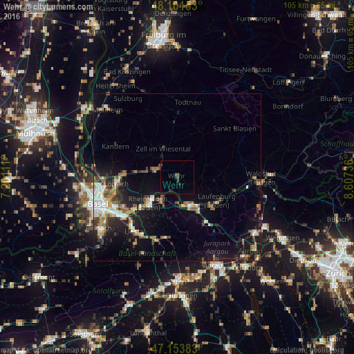
Analysis of Wehr night lights 2016
Square area 10x10 km:
 0%
0%90-99
0%80-89
0%70-79
0%60-69
0%50-59
0.15%40-49
2.23%30-39
1.64%20-29
0.74%10-19
0.6%0-9
94.64%Square area 50x50 km:
1.38%90-99
1.44%80-89
0.71%70-79
1.06%60-69
1.19%50-59
1.77%40-49
1.52%30-39
1.65%20-29
2.42%10-19
7.81%0-9
79.04%Clear (daylight) street map image can be seen on geolist.org.
Map coordinates:
48° 6' 5.5" North, 7° 12' 4" East
47° 37' 47.4" North, 7° 54' 15.2" East
47° 9' 13.8" North, 8° 36' 26.5" East
Some cities around Wehr sort by population:
• Rheinfelden
11.7 km =7.3 mi,  228°
228°
• Schopfheim
6.7 km =4.2 mi,  290°
290°
• Bad Säckingen
9 km =5.6 mi,  159°
159°
• Rheinfelden, CH
11.8 km =7.3 mi,  224°
224°
• Steinen
12.5 km =7.8 mi,  277°
277°
• Möhlin, CH
9.1 km =5.7 mi,  210°
210°
• Murg
12.1 km =7.5 mi,  133°
133°
• Zell im Wiesental
9.3 km =5.8 mi,  335°
335°
2813262 (p: 13,037)
Sources (retrieved 2019-11-25):
» Earth at Night: Flat Maps 2012, 2016