Schopfheim night lights from space
Night Light of Schopfheim (Baden-Württemberg) from space (Germany) Src. Average luminocity for 10x10km area is 5.7857% and for 50x50km: 12.0585%.
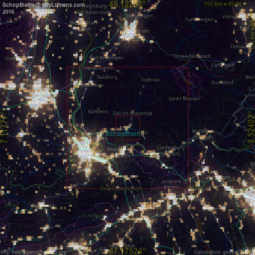
Analysis of Schopfheim night lights 2016
Square area 10x10 km:
 0%
0%90-99
0%80-89
0%70-79
0.74%60-69
1.04%50-59
0.89%40-49
3.13%30-39
1.93%20-29
0.6%10-19
0.6%0-9
91.07%Square area 50x50 km:
1.78%90-99
1.86%80-89
0.91%70-79
1.26%60-69
1.5%50-59
2.12%40-49
1.79%30-39
2.19%20-29
3.29%10-19
8.01%0-9
75.29%Clear (daylight) street map image can be seen on geolist.org.
Map coordinates:
48° 7' 21.2" North, 7° 7' 4" East
47° 39' 3.8" North, 7° 49' 15.2" East
47° 10' 30.9" North, 8° 31' 26.5" East
Some cities around Schopfheim sort by population:
• Lörrach
12.4 km =7.7 mi,  251°
251°
• Rheinfelden
10.4 km =6.5 mi,  194°
194°
• Wehr
6.7 km =4.2 mi,  110°
110°
• Rheinfelden, CH
10.9 km =6.8 mi, 190°
• Steinen
6.2 km =3.9 mi,  263°
263°
• Möhlin, CH
10.4 km =6.5 mi,  170°
170°
• Kandern
13.8 km =8.6 mi,  300°
300°
• Zell im Wiesental
6.5 km =4 mi,  21°
21°
2836413 (p: 19,386)
Sources (retrieved 2019-11-25):
» Earth at Night: Flat Maps 2012, 2016