Rheinfelden night lights from space
Night Light of Rheinfelden (Aargau) from space (Switzerland) Src. Average luminocity for 10x10km area is 22.4219% and for 50x50km: 15.0829%.
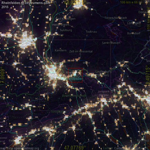
Analysis of Rheinfelden night lights 2016
Square area 10x10 km:
 2.84%
2.84%90-99
2.56%80-89
2.41%70-79
1.85%60-69
1.14%50-59
3.84%40-49
3.13%30-39
3.69%20-29
5.68%10-19
37.36%0-9
35.51%Square area 50x50 km:
2.05%90-99
2.41%80-89
1.06%70-79
1.7%60-69
2.01%50-59
2.49%40-49
2.2%30-39
2.42%20-29
4.58%10-19
11.61%0-9
67.46%Clear (daylight) street map image can be seen on geolist.org.
Map coordinates:
48° 1' 36.3" North, 7° 5' 27.2" East
47° 33' 15.7" North, 7° 47' 38.5" East
47° 4' 39.7" North, 8° 29' 49.7" East
Some cities around Rheinfelden sort by population:
• Pratteln
8.4 km =5.2 mi,  243°
243°
• Grenzach-Wyhlen, DE
8.3 km =5.2 mi,  266°
266°
• Liestal
9 km =5.6 mi,  209°
209°
• Steinen, DE
10.8 km =6.7 mi,  337°
337°
• Möhlin
3.7 km =2.3 mi,  81°
81°
• Frenkendorf
7.9 km =4.9 mi,  227°
227°
• Sissach
10.1 km =6.3 mi,  173°
173°
• Gelterkinden
10.8 km =6.7 mi,  156°
156°
2659060 (p: 10,733)
Sources (retrieved 2019-11-25):
» Earth at Night: Flat Maps 2012, 2016