Steinen night lights from space
Night Light of Steinen (Baden-Württemberg) from space (Germany) Src. Average luminocity for 10x10km area is 9.0313% and for 50x50km: 13.4556%.
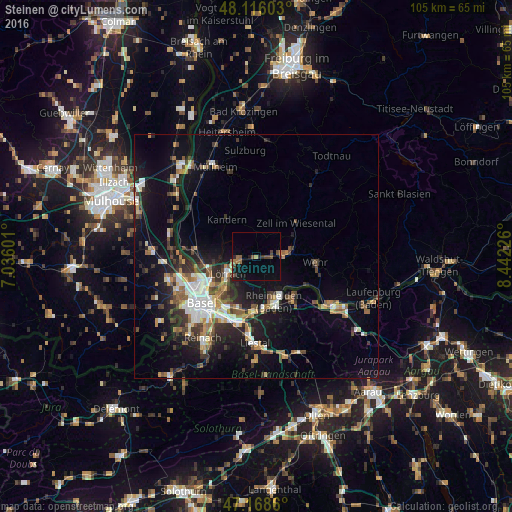
Analysis of Steinen night lights 2016
Square area 10x10 km:
 0%
0%90-99
0%80-89
0.6%70-79
0.45%60-69
2.83%50-59
1.79%40-49
2.83%30-39
1.64%20-29
1.93%10-19
5.8%0-9
82.14%Square area 50x50 km:
1.9%90-99
2.06%80-89
1.07%70-79
1.4%60-69
1.62%50-59
2.13%40-49
1.98%30-39
2.43%20-29
3.6%10-19
9.91%0-9
71.91%Clear (daylight) street map image can be seen on geolist.org.
Map coordinates:
48° 6' 57.7" North, 7° 2' 9.6" East
47° 38' 40.1" North, 7° 44' 20.9" East
47° 10' 7" North, 8° 26' 32.1" East
Some cities around Steinen sort by population:
• Lörrach
6.5 km =4 mi,  239°
239°
• Rheinfelden
10 km =6.2 mi,  158°
158°
• Weil am Rhein
10.5 km =6.5 mi, 237°
• Riehen, CH
10.1 km =6.3 mi,  223°
223°
• Schopfheim
6.2 km =3.9 mi,  83°
83°
• Rheinfelden, CH
10.8 km =6.7 mi, 157°
• Kandern
9.6 km =6 mi,  323°
323°
• Zell im Wiesental
10.9 km =6.8 mi,  51°
51°
2828228 (p: 10,128)
Sources (retrieved 2019-11-25):
» Earth at Night: Flat Maps 2012, 2016