Möhlin night lights from space
Night Light of Möhlin (Aargau) from space (Switzerland) Src. Average luminocity for 10x10km area is 15.1563% and for 50x50km: 14.2067%.
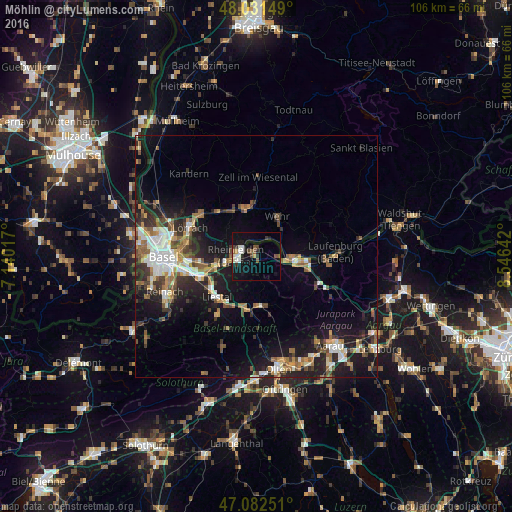
Analysis of Möhlin night lights 2016
Square area 10x10 km:
 2.41%
2.41%90-99
2.41%80-89
0.99%70-79
0.99%60-69
0%50-59
3.13%40-49
2.56%30-39
1.99%20-29
2.13%10-19
18.04%0-9
65.34%Square area 50x50 km:
2.06%90-99
2.28%80-89
1%70-79
1.55%60-69
1.9%50-59
2.45%40-49
2.01%30-39
2.29%20-29
4.14%10-19
10.74%0-9
69.58%Clear (daylight) street map image can be seen on geolist.org.
Map coordinates:
48° 1' 53.4" North, 7° 8' 24.6" East
47° 33' 32.9" North, 7° 50' 35.8" East
47° 4' 57" North, 8° 32' 47.1" East
Some cities around Möhlin sort by population:
• Rheinfelden, DE
4.2 km =2.6 mi,  271°
271°
• Schopfheim, DE
10.4 km =6.5 mi,  350°
350°
• Bad Säckingen, DE
7.7 km =4.8 mi,  94°
94°
• Wehr, DE
9.1 km =5.7 mi,  30°
30°
• Rheinfelden
3.7 km =2.3 mi,  261°
261°
• Frenkendorf
11.2 km =7 mi,  238°
238°
• Sissach
10.9 km =6.8 mi,  193°
193°
• Gelterkinden
10.5 km =6.5 mi,  176°
176°
2659645 (p: 9,382)
Sources (retrieved 2019-11-25):
» Earth at Night: Flat Maps 2012, 2016