Reilingen night lights from space
Night Light of Reilingen (Baden-Württemberg) from space (Germany) Src. Average luminocity for 10x10km area is 31.0441% and for 50x50km: 21.9263%.
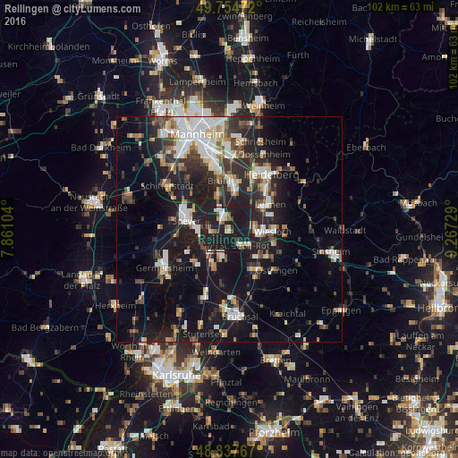
Analysis of Reilingen night lights 2016
Square area 10x10 km:
 3.61%
3.61%90-99
4.95%80-89
3.48%70-79
2.67%60-69
2.94%50-59
3.74%40-49
2.27%30-39
1.34%20-29
8.29%10-19
66.58%0-9
0.13%Square area 50x50 km:
3.79%90-99
4.26%80-89
1.79%70-79
1.67%60-69
2.42%50-59
2.3%40-49
2.71%30-39
3.15%20-29
7.69%10-19
20.42%0-9
49.82%Clear (daylight) street map image can be seen on geolist.org.
Map coordinates:
49° 45' 17" North, 7° 51' 39.7" East
49° 17' 54" North, 8° 33' 51" East
48° 50' 15.6" North, 9° 16' 2.2" East
Some cities around Reilingen sort by population:
• Hockenheim
2.9 km =1.8 mi,  342°
342°
• Waghäusel
6.6 km =4.1 mi,  214°
214°
• Walldorf
5.7 km =3.5 mi,  81°
81°
• Sankt Leon-Rot
5.3 km =3.3 mi,  132°
132°
• Oftersheim
7.6 km =4.7 mi,  10°
10°
• Oberhausen-Rheinhausen
7.2 km =4.5 mi,  247°
247°
• Neulußheim
3.3 km =2.1 mi,  269°
269°
• Altlußheim
4.7 km =2.9 mi, 274°
2848867 (p: 7,022)
Sources (retrieved 2019-11-25):
» Earth at Night: Flat Maps 2012, 2016