Waldmohr night lights from space
Night Light of Waldmohr (Rheinland-Pfalz) from space (Germany) Src. Average luminocity for 10x10km area is 19.0455% and for 50x50km: 11.0445%.
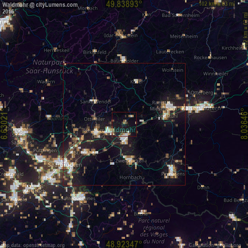
Analysis of Waldmohr night lights 2016
Square area 10x10 km:
 1.34%
1.34%90-99
1.74%80-89
3.34%70-79
1.47%60-69
1.74%50-59
2.94%40-49
3.88%30-39
2.01%20-29
4.81%10-19
26.47%0-9
50.27%Square area 50x50 km:
1.19%90-99
1.58%80-89
1.09%70-79
1.07%60-69
1.08%50-59
1.38%40-49
1.85%30-39
1.86%20-29
3.21%10-19
12.91%0-9
72.79%Clear (daylight) street map image can be seen on geolist.org.
Map coordinates:
49° 50' 20.1" North, 6° 37' 48.8" East
49° 22' 60" North, 7° 19' 60" East
48° 55' 24.5" North, 8° 2' 11.3" East
Some cities around Waldmohr sort by population:
• Neunkirchen
11.9 km =7.4 mi,  248°
248°
• Homburg
6.3 km =3.9 mi,  176°
176°
• Bexbach
7 km =4.3 mi,  233°
233°
• Schiffweiler
14.6 km =9.1 mi,  262°
262°
• Ottweiler
12.4 km =7.7 mi,  279°
279°
• Kirkel
13.3 km =8.3 mi,  213°
213°
• Bruchmühlbach-Miesau
7.2 km =4.5 mi,  90°
90°
• Schönenberg-Kübelberg
3.9 km =2.4 mi,  46°
46°
2814851 (p: 5,426)
Sources (retrieved 2019-11-25):
» Earth at Night: Flat Maps 2012, 2016