Bruchmühlbach-Miesau night lights from space
Night Light of Bruchmühlbach-Miesau (Rheinland-Pfalz) from space (Germany) Src. Average luminocity for 10x10km area is 7.3703% and for 50x50km: 9.7622%.
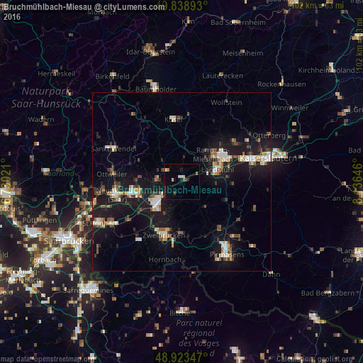
Analysis of Bruchmühlbach-Miesau night lights 2016
Square area 10x10 km:
 0.27%
0.27%90-99
1.6%80-89
0.8%70-79
0%60-69
1.07%50-59
1.07%40-49
1.07%30-39
0.53%20-29
0.8%10-19
6.28%0-9
86.5%Square area 50x50 km:
1.18%90-99
1.46%80-89
0.98%70-79
0.83%60-69
0.88%50-59
1.09%40-49
1.53%30-39
1.26%20-29
2.14%10-19
12.66%0-9
76%Clear (daylight) street map image can be seen on geolist.org.
Map coordinates:
49° 50' 20.1" North, 6° 43' 48.8" East
49° 22' 60" North, 7° 25' 60" East
48° 55' 24.5" North, 8° 8' 11.3" East
Some cities around Bruchmühlbach-Miesau sort by population:
• Homburg
9.3 km =5.8 mi,  227°
227°
• Zweibrücken
15.9 km =9.9 mi,  196°
196°
• Bexbach
13.5 km =8.4 mi,  252°
252°
• Landstuhl
10.4 km =6.5 mi,  71°
71°
• Ramstein-Miesenbach
11.1 km =6.9 mi,  52°
52°
• Schönenberg-Kübelberg
5.2 km =3.2 mi,  301°
301°
• Waldmohr
7.2 km =4.5 mi,  270°
270°
• Contwig
14.8 km =9.2 mi,  180°
180°
3207512 (p: 7,800)
Sources (retrieved 2019-11-25):
» Earth at Night: Flat Maps 2012, 2016