Schiffweiler night lights from space
Night Light of Schiffweiler (Saarland) from space (Germany) Src. Average luminocity for 10x10km area is 24.5334% and for 50x50km: 13.9354%.
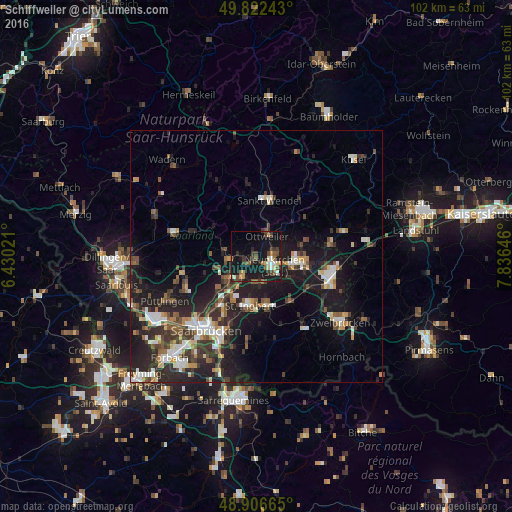
Analysis of Schiffweiler night lights 2016
Square area 10x10 km:
 1.87%
1.87%90-99
2.41%80-89
2.81%70-79
2.67%60-69
2.67%50-59
4.28%40-49
4.81%30-39
6.02%20-29
4.14%10-19
37.3%0-9
31.02%Square area 50x50 km:
1.82%90-99
2.14%80-89
1.12%70-79
1.34%60-69
1.27%50-59
1.96%40-49
2.45%30-39
2.79%20-29
5.67%10-19
12.88%0-9
66.56%Clear (daylight) street map image can be seen on geolist.org.
Map coordinates:
49° 49' 20.7" North, 6° 25' 48.8" East
49° 22' 0" North, 7° 7' 60" East
48° 54' 23.9" North, 7° 50' 11.3" East
Some cities around Schiffweiler sort by population:
• Neunkirchen
4.2 km =2.6 mi,  125°
125°
• Bexbach
9.1 km =5.7 mi,  104°
104°
• Illingen
6.3 km =3.9 mi,  277°
277°
• Ottweiler
4.5 km =2.8 mi,  30°
30°
• Spiesen-Elversberg
5.6 km =3.5 mi,  180°
180°
• Quierschied
8.2 km =5.1 mi,  227°
227°
• Friedrichsthal
5.1 km =3.2 mi,  211°
211°
• Merchweiler
6.3 km =3.9 mi,  252°
252°
2839316 (p: 15,780)
Sources (retrieved 2019-11-25):
» Earth at Night: Flat Maps 2012, 2016