Kirkel night lights from space
Night Light of Kirkel (Saarland) from space (Germany) Src. Average luminocity for 10x10km area is 11.611% and for 50x50km: 14.2081%.
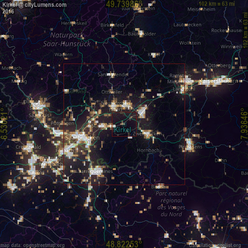
Analysis of Kirkel night lights 2016
Square area 10x10 km:
 0%
0%90-99
1.07%80-89
0.53%70-79
0%60-69
0%50-59
1.07%40-49
1.34%30-39
2.67%20-29
3.88%10-19
33.56%0-9
55.88%Square area 50x50 km:
1.77%90-99
2.17%80-89
1.21%70-79
1.4%60-69
1.42%50-59
1.78%40-49
2.39%30-39
2.8%20-29
5.01%10-19
14.43%0-9
65.61%Clear (daylight) street map image can be seen on geolist.org.
Map coordinates:
49° 44' 23.5" North, 6° 31' 48.8" East
49° 16' 60" North, 7° 13' 60" East
48° 49' 21.1" North, 7° 56' 11.3" East
Some cities around Kirkel sort by population:
• Neunkirchen
7.8 km =4.8 mi,  330°
330°
• Homburg
9 km =5.6 mi,  57°
57°
• Sankt Ingbert
8.5 km =5.3 mi,  265°
265°
• Zweibrücken
10.7 km =6.6 mi,  112°
112°
• Blieskastel
5.4 km =3.4 mi,  162°
162°
• Bexbach
7.2 km =4.5 mi,  12°
12°
• Spiesen-Elversberg
8.1 km =5 mi,  297°
297°
• Friedrichsthal
11.1 km =6.9 mi, 296°
2890322 (p: 10,330)
Sources (retrieved 2019-11-25):
» Earth at Night: Flat Maps 2012, 2016