Rheurdt night lights from space
Night Light of Rheurdt (North Rhine-Westphalia) from space (Germany) Src. Average luminocity for 10x10km area is 4.7968% and for 50x50km: 25.343%.
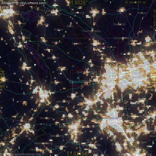
Analysis of Rheurdt night lights 2016
Square area 10x10 km:
 0%
0%90-99
0%80-89
0%70-79
0%60-69
0.94%50-59
1.6%40-49
2.81%30-39
0.53%20-29
0.53%10-19
0.8%0-9
92.78%Square area 50x50 km:
5.14%90-99
5.4%80-89
2.17%70-79
2.41%60-69
2.59%50-59
3.5%40-49
3.66%30-39
4.62%20-29
6.56%10-19
11.91%0-9
52.05%Clear (daylight) street map image can be seen on geolist.org.
Map coordinates:
51° 54' 9.4" North, 5° 45' 48.7" East
51° 28' 0" North, 6° 28' 0" East
51° 1' 35.5" North, 7° 10' 11.2" East
Some cities around Rheurdt sort by population:
• Moers
11.6 km =7.2 mi,  97°
97°
• Kamp-Lintfort
6.9 km =4.3 mi,  52°
52°
• Kempen
11.9 km =7.4 mi,  196°
196°
• Geldern
11.5 km =7.1 mi,  300°
300°
• Rheinberg
12.6 km =7.8 mi, 45°
• Alpen
13.4 km =8.3 mi,  14°
14°
• Issum
7.8 km =4.8 mi,  342°
342°
• Wachtendonk
10.9 km =6.8 mi,  234°
234°
2847586 (p: 6,669)
Sources (retrieved 2019-11-25):
» Earth at Night: Flat Maps 2012, 2016