Verl night lights from space
Night Light of Verl (North Rhine-Westphalia) from space (Germany) Src. Average luminocity for 10x10km area is 7.0227% and for 50x50km: 9.7393%.
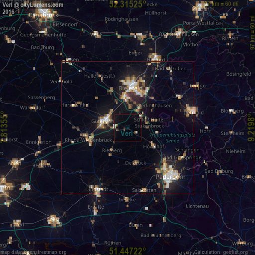

Analysis of Verl night lights 2016
Square area 10x10 km:
 1.52%
1.52%90-99
0.76%80-89
0.51%70-79
0.51%60-69
0.51%50-59
0.13%40-49
1.14%30-39
0%20-29
0.88%10-19
4.67%0-9
89.39%Square area 50x50 km:
1.11%90-99
1.42%80-89
1.02%70-79
1%60-69
1.37%50-59
1.42%40-49
1.44%30-39
1.05%20-29
2.57%10-19
7.81%0-9
79.8%Clear (daylight) street map image can be seen on geolist.org.
Map coordinates:
52° 18' 54.9" North, 7° 48' 48.8" East
51° 52' 60" North, 8° 31' 0" East
51° 26' 50" North, 9° 13' 11.3" East
Some cities around Verl sort by population:
• Gütersloh
9.8 km =6.1 mi,  285°
285°
• Rheda-Wiedenbrück
15.3 km =9.5 mi,  255°
255°
• Delbrück
13.5 km =8.4 mi,  166°
166°
• Rietberg
10.2 km =6.3 mi,  216°
216°
• Steinhagen
15.2 km =9.4 mi,  328°
328°
• Oerlinghausen
12.7 km =7.9 mi,  51°
51°
• Hövelhof
11.8 km =7.3 mi,  128°
128°
• Augustdorf
15 km =9.3 mi,  78°
78°
2817576 (p: 24,002)
Sources (retrieved 2019-11-25):
» Earth at Night: Flat Maps 2012, 2016