Augustdorf night lights from space
Night Light of Augustdorf (North Rhine-Westphalia) from space (Germany) Src. Average luminocity for 10x10km area is 2.8548% and for 50x50km: 8.8739%.
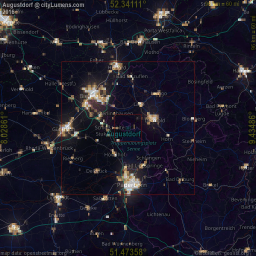
Analysis of Augustdorf night lights 2016
Square area 10x10 km:
 0.13%
0.13%90-99
0.38%80-89
0.51%70-79
0%60-69
0%50-59
0.76%40-49
1.01%30-39
0.76%20-29
0.51%10-19
0.51%0-9
95.45%Square area 50x50 km:
1.05%90-99
1.39%80-89
0.94%70-79
0.95%60-69
1.23%50-59
1.24%40-49
1.3%30-39
0.94%20-29
2.34%10-19
6.95%0-9
81.68%Clear (daylight) street map image can be seen on geolist.org.
Map coordinates:
52° 20' 28" North, 8° 1' 43" East
51° 54' 34" North, 8° 43' 54.2" East
51° 28' 24.9" North, 9° 26' 5.5" East
Some cities around Augustdorf sort by population:
• Detmold
10.2 km =6.3 mi,  71°
71°
• Lage
10.1 km =6.3 mi,  24°
24°
• Verl
15 km =9.3 mi,  258°
258°
• Oerlinghausen
6.9 km =4.3 mi,  316°
316°
• Leopoldshöhe
11.7 km =7.3 mi,  348°
348°
• Hövelhof
11.7 km =7.3 mi,  208°
208°
• Schlangen
13.6 km =8.5 mi,  144°
144°
• Horn
15.2 km =9.4 mi,  106°
106°
2954164 (p: 9,889)
Sources (retrieved 2019-11-25):
» Earth at Night: Flat Maps 2012, 2016