Hövelhof night lights from space
Night Light of Hövelhof (North Rhine-Westphalia) from space (Germany) Src. Average luminocity for 10x10km area is 5.1989% and for 50x50km: 9.2267%.
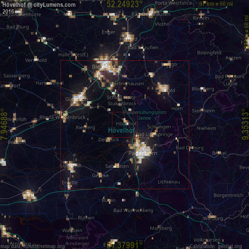
Analysis of Hövelhof night lights 2016
Square area 10x10 km:
 0.28%
0.28%90-99
0.28%80-89
1.12%70-79
0.56%60-69
0.56%50-59
0%40-49
0.56%30-39
0.84%20-29
0.84%10-19
3.36%0-9
91.6%Square area 50x50 km:
1.1%90-99
1.39%80-89
0.98%70-79
1.05%60-69
1.27%50-59
1.33%40-49
1.36%30-39
0.91%20-29
2.2%10-19
6.82%0-9
81.6%Clear (daylight) street map image can be seen on geolist.org.
Map coordinates:
52° 14' 57.2" North, 7° 56' 48.8" East
51° 49' 0" North, 8° 39' 0" East
51° 22' 47.7" North, 9° 21' 11.3" East
Some cities around Hövelhof sort by population:
• Paderborn
13 km =8.1 mi,  146°
146°
• Delbrück
8.3 km =5.2 mi,  226°
226°
• Rietberg
15.3 km =9.5 mi,  266°
266°
• Verl
11.8 km =7.3 mi,  308°
308°
• Oerlinghausen
15.4 km =9.6 mi,  3°
3°
• Bad Lippspringe
12.1 km =7.5 mi,  107°
107°
• Augustdorf
11.7 km =7.3 mi,  28°
28°
• Schlangen
13.5 km =8.4 mi,  93°
93°
2898364 (p: 15,962)
Sources (retrieved 2019-11-25):
» Earth at Night: Flat Maps 2012, 2016