Stein night lights from space
Night Light of Stein (Bavaria) from space (Germany) Src. Average luminocity for 10x10km area is 61.516% and for 50x50km: 13.8197%.
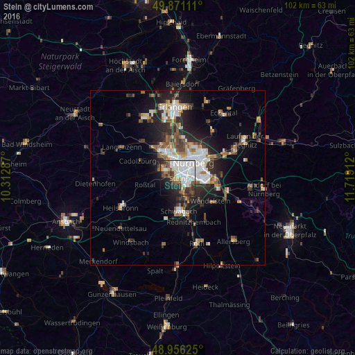
Analysis of Stein night lights 2016
Square area 10x10 km:
 23.8%
23.8%90-99
14.84%80-89
3.07%70-79
3.21%60-69
6.95%50-59
7.09%40-49
5.88%30-39
9.49%20-29
10.16%10-19
9.76%0-9
5.75%Square area 50x50 km:
2.84%90-99
2.31%80-89
1.19%70-79
1.2%60-69
1.63%50-59
2.02%40-49
1.96%30-39
2.21%20-29
4.41%10-19
6.96%0-9
73.24%Clear (daylight) street map image can be seen on geolist.org.
Map coordinates:
49° 52' 16" North, 10° 18' 46.3" East
49° 24' 56.9" North, 11° 0' 57.6" East
48° 57' 22.5" North, 11° 43' 8.8" East
Some cities around Stein sort by population:
• Nürnberg
6.2 km =3.9 mi,  46°
46°
• Fürth
7 km =4.3 mi,  343°
343°
• Schwabach
9.5 km =5.9 mi,  176°
176°
• Zirndorf
5.4 km =3.4 mi,  303°
303°
• Oberasbach
4.3 km =2.7 mi,  280°
280°
• Wendelstein
12 km =7.5 mi,  125°
125°
• Roßtal
9.5 km =5.9 mi,  256°
256°
• Wetzendorf
6.4 km =4 mi,  16°
16°
2828685 (p: 13,902)
Sources (retrieved 2019-11-25):
» Earth at Night: Flat Maps 2012, 2016