Roßtal night lights from space
Night Light of Roßtal (Bavaria) from space (Germany) Src. Average luminocity for 10x10km area is 2.5709% and for 50x50km: 13.4109%.
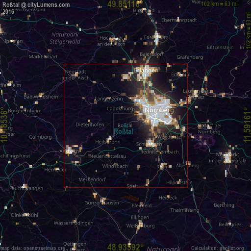
Analysis of Roßtal night lights 2016
Square area 10x10 km:
 0%
0%90-99
0%80-89
0%70-79
0.27%60-69
0.94%50-59
0.27%40-49
0.27%30-39
0.13%20-29
0.13%10-19
4.68%0-9
93.32%Square area 50x50 km:
2.93%90-99
2.33%80-89
1.18%70-79
1.16%60-69
1.62%50-59
1.81%40-49
1.8%30-39
2.09%20-29
4.15%10-19
6.53%0-9
74.4%Clear (daylight) street map image can be seen on geolist.org.
Map coordinates:
49° 51' 4.2" North, 10° 11' 7.3" East
49° 23' 44.4" North, 10° 53' 18.5" East
48° 56' 9.3" North, 11° 35' 29.8" East
Some cities around Roßtal sort by population:
• Fürth
11.5 km =7.1 mi,  39°
39°
• Schwabach
12.2 km =7.6 mi,  126°
126°
• Zirndorf
7 km =4.3 mi, 42°
• Oberasbach
5.8 km =3.6 mi,  58°
58°
• Stein
9.5 km =5.9 mi,  76°
76°
• Langenzenn
13 km =8.1 mi,  327°
327°
• Cadolzburg
7.3 km =4.5 mi,  339°
339°
• Heilsbronn
9.9 km =6.2 mi,  227°
227°
2844616 (p: 10,052)
Sources (retrieved 2019-11-25):
» Earth at Night: Flat Maps 2012, 2016