Schwaigern night lights from space
Night Light of Schwaigern (Baden-Württemberg) from space (Germany) Src. Average luminocity for 10x10km area is 8.1275% and for 50x50km: 11.9846%.
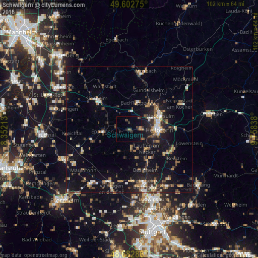
Analysis of Schwaigern night lights 2016
Square area 10x10 km:
 0%
0%90-99
0%80-89
0.56%70-79
1.96%60-69
1.96%50-59
0%40-49
2.24%30-39
2.8%20-29
1.12%10-19
1.96%0-9
87.39%Square area 50x50 km:
1.15%90-99
1.27%80-89
1.09%70-79
1.32%60-69
1.62%50-59
1.92%40-49
1.77%30-39
2.09%20-29
2.98%10-19
10.91%0-9
73.86%Clear (daylight) street map image can be seen on geolist.org.
Map coordinates:
49° 36' 9.9" North, 8° 21' 7.7" East
49° 8' 41.8" North, 9° 3' 18.9" East
48° 40' 58.3" North, 9° 45' 30.2" East
Some cities around Schwaigern sort by population:
• Eppingen
10.4 km =6.5 mi,  264°
264°
• Bad Rappenau
10.9 km =6.8 mi,  18°
18°
• Brackenheim
7.5 km =4.7 mi,  174°
174°
• Lauffen am Neckar
10.3 km =6.4 mi,  140°
140°
• Leingarten
4.5 km =2.8 mi,  87°
87°
• Nordheim
6.6 km =4.1 mi,  127°
127°
• Güglingen
9.6 km =6 mi,  204°
204°
• Kirchardt
8.1 km =5 mi,  325°
325°
2835411 (p: 11,047)
Sources (retrieved 2019-11-25):
» Earth at Night: Flat Maps 2012, 2016