Kirchardt night lights from space
Night Light of Kirchardt (Baden-Württemberg) from space (Germany) Src. Average luminocity for 10x10km area is 3.5588% and for 50x50km: 11.3003%.
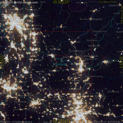
Analysis of Kirchardt night lights 2016
Square area 10x10 km:
 0%
0%90-99
0%80-89
0%70-79
0%60-69
0%50-59
0.56%40-49
1.68%30-39
2.52%20-29
2.1%10-19
0.14%0-9
93%Square area 50x50 km:
1.24%90-99
1.38%80-89
0.92%70-79
1.08%60-69
1.51%50-59
1.83%40-49
1.69%30-39
1.88%20-29
3.29%10-19
8.72%0-9
76.45%Clear (daylight) street map image can be seen on geolist.org.
Map coordinates:
49° 39' 44.1" North, 8° 17' 18.8" East
49° 12' 18" North, 8° 59' 30" East
48° 44' 36.5" North, 9° 41' 41.3" East
Some cities around Kirchardt sort by population:
• Sinsheim
9.8 km =6.1 mi,  302°
302°
• Eppingen
9.6 km =6 mi,  217°
217°
• Bad Rappenau
8.8 km =5.5 mi,  65°
65°
• Schwaigern
8.1 km =5 mi,  145°
145°
• Leingarten
11.2 km =7 mi,  125°
125°
• Nordheim
14.6 km =9.1 mi,  137°
137°
• Bad Wimpfen
12.3 km =7.6 mi,  77°
77°
• Waibstadt
11.4 km =7.1 mi,  331°
331°
2890769 (p: 5,592)
Sources (retrieved 2019-11-25):
» Earth at Night: Flat Maps 2012, 2016