Nordheim night lights from space
Night Light of Nordheim (Baden-Württemberg) from space (Germany) Src. Average luminocity for 10x10km area is 20.9608% and for 50x50km: 13.2578%.
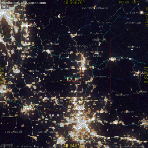
Analysis of Nordheim night lights 2016
Square area 10x10 km:
 0.14%
0.14%90-99
0.56%80-89
1.96%70-79
3.5%60-69
4.48%50-59
5.46%40-49
2.94%30-39
3.92%20-29
7.28%10-19
22.55%0-9
47.2%Square area 50x50 km:
1.41%90-99
1.74%80-89
1.2%70-79
1.38%60-69
1.72%50-59
1.95%40-49
1.99%30-39
2.38%20-29
3.64%10-19
10.73%0-9
71.87%Clear (daylight) street map image can be seen on geolist.org.
Map coordinates:
49° 34' 0.3" North, 8° 25' 28.8" East
49° 6' 31" North, 9° 7' 40" East
48° 38' 46.3" North, 9° 49' 51.3" East
Some cities around Nordheim sort by population:
• Heilbronn
7.6 km =4.7 mi,  62°
62°
• Brackenheim
5.6 km =3.5 mi,  232°
232°
• Lauffen am Neckar
4.1 km =2.5 mi,  161°
161°
• Schwaigern
6.6 km =4.1 mi,  307°
307°
• Leingarten
4.3 km =2.7 mi,  349°
349°
• Bönnigheim
8 km =5 mi,  197°
197°
• Flein
6.1 km =3.8 mi,  95°
95°
• Kirchheim am Neckar
7.2 km =4.5 mi,  171°
171°
2861973 (p: 7,440)
Sources (retrieved 2019-11-25):
» Earth at Night: Flat Maps 2012, 2016