Lauffen am Neckar night lights from space
Night Light of Lauffen am Neckar (Baden-Württemberg) from space (Germany) Src. Average luminocity for 10x10km area is 18.2247% and for 50x50km: 15.3195%.
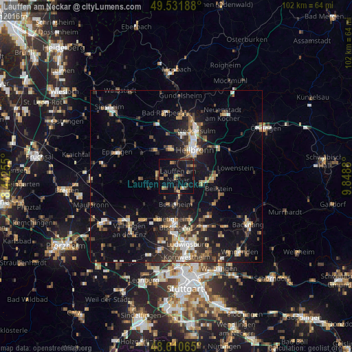
Analysis of Lauffen am Neckar night lights 2016
Square area 10x10 km:
 0.3%
0.3%90-99
0.3%80-89
1.34%70-79
2.23%60-69
3.57%50-59
4.91%40-49
3.57%30-39
2.53%20-29
4.32%10-19
20.98%0-9
55.95%Square area 50x50 km:
1.74%90-99
2.02%80-89
1.31%70-79
1.62%60-69
2.14%50-59
2.21%40-49
2.5%30-39
2.67%20-29
4.5%10-19
11.88%0-9
67.4%Clear (daylight) street map image can be seen on geolist.org.
Map coordinates:
49° 31' 54.8" North, 8° 26' 33.2" East
49° 4' 24.2" North, 9° 8' 44.4" East
48° 36' 38.3" North, 9° 50' 55.7" East
Some cities around Lauffen am Neckar sort by population:
• Brackenheim
5.8 km =3.6 mi,  274°
274°
• Besigheim
8.4 km =5.2 mi,  181°
181°
• Ilsfeld
7.6 km =4.7 mi,  105°
105°
• Bönnigheim
5.3 km =3.3 mi,  225°
225°
• Nordheim
4.1 km =2.5 mi,  341°
341°
• Flein
5.8 km =3.6 mi,  55°
55°
• Löchgau
8.3 km =5.2 mi,  200°
200°
• Kirchheim am Neckar
3.2 km =2 mi, 184°
2880111 (p: 11,068)
Sources (retrieved 2019-11-25):
» Earth at Night: Flat Maps 2012, 2016