Leingarten night lights from space
Night Light of Leingarten (Baden-Württemberg) from space (Germany) Src. Average luminocity for 10x10km area is 18.3697% and for 50x50km: 11.372%.
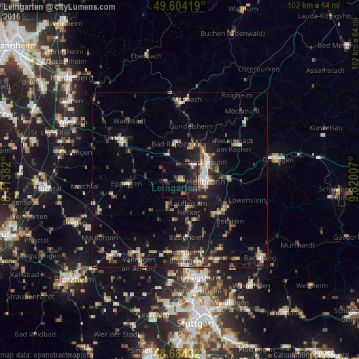
Analysis of Leingarten night lights 2016
Square area 10x10 km:
 1.54%
1.54%90-99
0.7%80-89
1.4%70-79
2.24%60-69
3.08%50-59
0.84%40-49
3.5%30-39
5.04%20-29
9.52%10-19
20.87%0-9
51.26%Square area 50x50 km:
1.14%90-99
1.27%80-89
1.06%70-79
1.24%60-69
1.46%50-59
1.85%40-49
1.71%30-39
2.14%20-29
3.03%10-19
9.11%0-9
75.98%Clear (daylight) street map image can be seen on geolist.org.
Map coordinates:
49° 36' 15.1" North, 8° 24' 49.8" East
49° 8' 47" North, 9° 7' 1" East
48° 41' 3.6" North, 9° 49' 12.3" East
Some cities around Leingarten sort by population:
• Heilbronn
7.6 km =4.7 mi,  95°
95°
• Neckarsulm
9.2 km =5.7 mi,  58°
58°
• Brackenheim
8.5 km =5.3 mi,  205°
205°
• Lauffen am Neckar
8.4 km =5.2 mi,  165°
165°
• Schwaigern
4.5 km =2.8 mi,  267°
267°
• Nordheim
4.3 km =2.7 mi, 169°
• Bad Wimpfen
9.7 km =6 mi,  17°
17°
• Flein
8.4 km =5.2 mi,  125°
125°
3274259 (p: 10,579)
Sources (retrieved 2019-11-25):
» Earth at Night: Flat Maps 2012, 2016