Brackenheim night lights from space
Night Light of Brackenheim (Baden-Württemberg) from space (Germany) Src. Average luminocity for 10x10km area is 9.105% and for 50x50km: 15.72%.
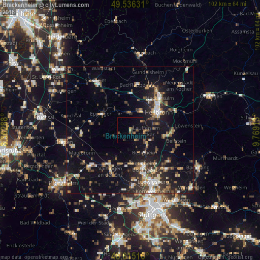
Analysis of Brackenheim night lights 2016
Square area 10x10 km:
 0%
0%90-99
0%80-89
0.98%70-79
0.98%60-69
1.96%50-59
3.22%40-49
1.4%30-39
0.98%20-29
1.12%10-19
2.24%0-9
87.11%Square area 50x50 km:
1.69%90-99
2.05%80-89
1.38%70-79
1.66%60-69
2.27%50-59
2.2%40-49
2.47%30-39
2.66%20-29
4.39%10-19
13.39%0-9
65.84%Clear (daylight) street map image can be seen on geolist.org.
Map coordinates:
49° 32' 10.7" North, 8° 21' 46.4" East
49° 4' 40.3" North, 9° 3' 57.6" East
48° 36' 54.6" North, 9° 46' 8.9" East
Some cities around Brackenheim sort by population:
• Lauffen am Neckar
5.8 km =3.6 mi,  94°
94°
• Schwaigern
7.5 km =4.7 mi,  354°
354°
• Leingarten
8.5 km =5.3 mi,  25°
25°
• Bönnigheim
4.7 km =2.9 mi,  154°
154°
• Nordheim
5.6 km =3.5 mi,  52°
52°
• Güglingen
4.9 km =3 mi,  254°
254°
• Löchgau
8.8 km =5.5 mi,  160°
160°
• Kirchheim am Neckar
6.6 km =4.1 mi,  123°
123°
2945591 (p: 15,083)
Sources (retrieved 2019-11-25):
» Earth at Night: Flat Maps 2012, 2016