Güglingen night lights from space
Night Light of Güglingen (Baden-Württemberg) from space (Germany) Src. Average luminocity for 10x10km area is 3.2902% and for 50x50km: 18.004%.
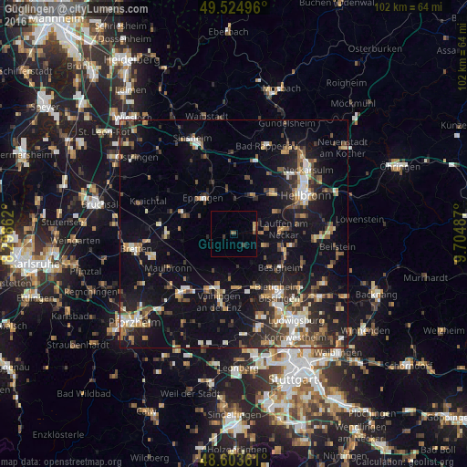
Analysis of Güglingen night lights 2016
Square area 10x10 km:
 0%
0%90-99
0%80-89
0.74%70-79
0.45%60-69
0.45%50-59
0.6%40-49
0.89%30-39
1.04%20-29
0%10-19
0.6%0-9
95.24%Square area 50x50 km:
1.91%90-99
2.55%80-89
1.6%70-79
2%60-69
2.6%50-59
2.52%40-49
2.93%30-39
2.83%20-29
5.33%10-19
14.71%0-9
61.02%Clear (daylight) street map image can be seen on geolist.org.
Map coordinates:
49° 31' 29.9" North, 8° 17' 55" East
49° 3' 59.1" North, 9° 0' 6.3" East
48° 36' 13" North, 9° 42' 17.5" East
Some cities around Güglingen sort by population:
• Eppingen
10.2 km =6.3 mi,  320°
320°
• Brackenheim
4.9 km =3 mi,  74°
74°
• Lauffen am Neckar
10.5 km =6.5 mi,  85°
85°
• Schwaigern
9.6 km =6 mi,  24°
24°
• Bönnigheim
7.3 km =4.5 mi,  113°
113°
• Nordheim
10.3 km =6.4 mi,  62°
62°
• Löchgau
10.3 km =6.4 mi,  132°
132°
• Kirchheim am Neckar
10.5 km =6.5 mi,  103°
103°
2913838 (p: 6,198)
Sources (retrieved 2019-11-25):
» Earth at Night: Flat Maps 2012, 2016