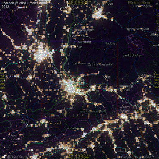
Lörrach night lights from space
Night Light of Lörrach (Baden-Württemberg) from space (Germany) Src. Average luminocity for 10x10km area is 31.598% and for 50x50km: 15.8011%.
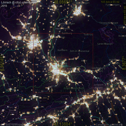
Analysis of Lörrach night lights 2016
Square area 10x10 km:
 4.26%
4.26%90-99
2.98%80-89
1.7%70-79
2.98%60-69
6.68%50-59
6.82%40-49
6.53%30-39
6.25%20-29
12.78%10-19
26.28%0-9
22.73%Square area 50x50 km:
2.5%90-99
2.63%80-89
1.19%70-79
1.55%60-69
1.77%50-59
2.48%40-49
2.3%30-39
3.04%20-29
4.39%10-19
10.7%0-9
67.46%Clear (daylight) street map image can be seen on geolist.org.
Map coordinates:
48° 5' 12.5" North, 6° 57' 41.2" East
47° 36' 53.9" North, 7° 39' 52.5" East
47° 8' 19.8" North, 8° 22' 3.7" East
Some cities around Lörrach sort by population:
• Weil am Rhein
4.1 km =2.5 mi,  233°
233°
• Saint-Louis, FR
8.3 km =5.2 mi,  252°
252°
• Riehen, CH
4.2 km =2.6 mi,  198°
198°
• Grenzach-Wyhlen
7.4 km =4.6 mi,  168°
168°
• Birsfelden, CH
7.6 km =4.7 mi, 204°
• Steinen
6.5 km =4 mi,  59°
59°
• Efringen-Kirchen
8.3 km =5.2 mi,  297°
297°
• Huningue, FR
6.6 km =4.1 mi,  260°
260°
2875881 (p: 47,002)
Sources (retrieved 2019-11-25):
» Earth at Night: Flat Maps 2012, 2016