Ruppichteroth night lights from space
Night Light of Ruppichteroth (North Rhine-Westphalia) from space (Germany) Src. Average luminocity for 10x10km area is 0.2521% and for 50x50km: 6.6401%.
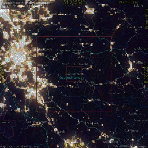
Analysis of Ruppichteroth night lights 2016
Square area 10x10 km:
 0%
0%90-99
0%80-89
0%70-79
0%60-69
0%50-59
0%40-49
0%30-39
0%20-29
0.56%10-19
0.56%0-9
98.88%Square area 50x50 km:
0.72%90-99
1.18%80-89
0.78%70-79
0.53%60-69
0.91%50-59
0.96%40-49
0.93%30-39
1.58%20-29
2%10-19
4.56%0-9
85.85%Clear (daylight) street map image can be seen on geolist.org.
Map coordinates:
51° 17' 7.9" North, 6° 46' 51.5" East
50° 50' 37.2" North, 7° 29' 2.7" East
50° 23' 51.3" North, 8° 11' 14" East
Some cities around Ruppichteroth sort by population:
• Hennef
16 km =9.9 mi,  241°
241°
• Overath
17.2 km =10.7 mi,  305°
305°
• Wiehl
12.7 km =7.9 mi,  21°
21°
• Engelskirchen
16.8 km =10.4 mi,  343°
343°
• Eitorf
8.9 km =5.5 mi,  195°
195°
• Waldbröl
10 km =6.2 mi,  69°
69°
• Nümbrecht
7.8 km =4.8 mi,  30°
30°
• Much
8.8 km =5.5 mi,  319°
319°
2842960 (p: 10,749)
Sources (retrieved 2019-11-25):
» Earth at Night: Flat Maps 2012, 2016