Rothenburg night lights from space
Night Light of Rothenburg (Saxony) from space (Germany) Src. Average luminocity for 10x10km area is 0% and for 50x50km: 2.5539%.
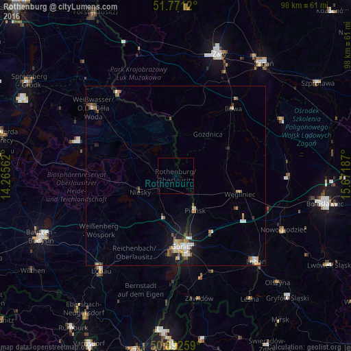
Analysis of Rothenburg night lights 2016
Square area 10x10 km:
 0%
0%90-99
0%80-89
0%70-79
0%60-69
0%50-59
0%40-49
0%30-39
0%20-29
0%10-19
0%0-9
100%Square area 50x50 km:
0.45%90-99
0.44%80-89
0.15%70-79
0.29%60-69
0.4%50-59
0.38%40-49
0.33%30-39
0.21%20-29
0.37%10-19
1.7%0-9
95.28%Clear (daylight) street map image can be seen on geolist.org.
Map coordinates:
51° 46' 16.3" North, 14° 15' 56.2" East
51° 20' 2.4" North, 14° 58' 7.5" East
50° 53' 33.3" North, 15° 40' 18.7" East
Some cities around Rothenburg sort by population:
• Görlitz
19.9 km =12.4 mi,  176°
176°
• Żary, PL
36.2 km =22.5 mi,  18°
18°
• Zgorzelec, PL
20.7 km =12.9 mi,  172°
172°
• Lubań, PL
32.5 km =20.2 mi,  136°
136°
• Weißwasser
29.6 km =18.4 mi,  309°
309°
• Löbau
33.5 km =20.8 mi,  218°
218°
• Niesky
11.3 km =7 mi,  245°
245°
• Pieńsk, PL
10.9 km =6.8 mi,  150°
150°
2844062 (p: 5,841)
Sources (retrieved 2019-11-25):
» Earth at Night: Flat Maps 2012, 2016