Pieńsk night lights from space
Night Light of Pieńsk (Lower Silesia) from space (Poland) Src. Average luminocity for 10x10km area is 3.2731% and for 50x50km: 2.6262%.
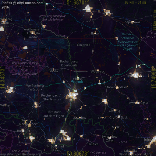
Analysis of Pieńsk night lights 2016
Square area 10x10 km:
 0.42%
0.42%90-99
0.14%80-89
0.56%70-79
0%60-69
0.14%50-59
0.98%40-49
0.56%30-39
0%20-29
0%10-19
0.56%0-9
96.64%Square area 50x50 km:
0.45%90-99
0.4%80-89
0.17%70-79
0.35%60-69
0.37%50-59
0.34%40-49
0.28%30-39
0.22%20-29
0.4%10-19
1.84%0-9
95.18%Clear (daylight) street map image can be seen on geolist.org.
Map coordinates:
51° 41' 13.2" North, 14° 20' 37.4" East
51° 14' 56.4" North, 15° 2' 48.7" East
50° 48' 24.4" North, 15° 44' 59.9" East
Some cities around Pieńsk sort by population:
• Görlitz, DE
11.2 km =7 mi,  201°
201°
• Bolesławiec
36.4 km =22.6 mi,  87°
87°
• Zgorzelec
11.4 km =7.1 mi,  193°
193°
• Lubań
22.1 km =13.7 mi,  130°
130°
• Löbau, DE
31.2 km =19.4 mi,  237°
237°
• Niesky, DE
16.4 km =10.2 mi,  287°
287°
• Gryfów Śląski
35.6 km =22.1 mi, 132°
• Rothenburg, DE
10.9 km =6.8 mi,  330°
330°
3089098 (p: 5,813)
Sources (retrieved 2019-11-25):
» Earth at Night: Flat Maps 2012, 2016