Issum night lights from space
Night Light of Issum (North Rhine-Westphalia) from space (Germany) Src. Average luminocity for 10x10km area is 0.7914% and for 50x50km: 19.96%.
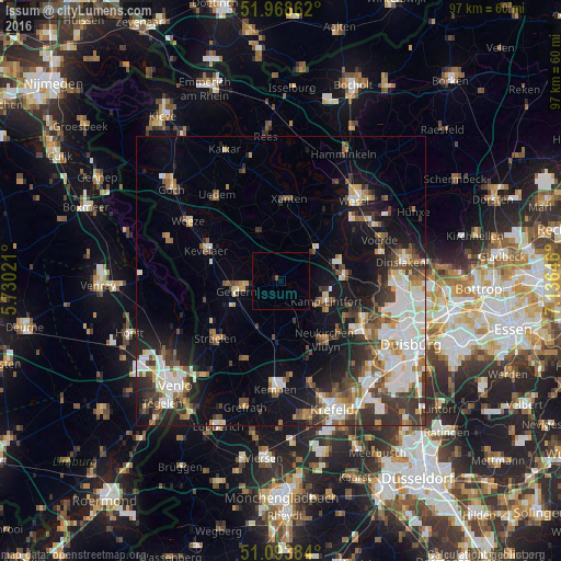
Analysis of Issum night lights 2016
Square area 10x10 km:
100  0%
0%
90-99 0%
80-89 0%
70-79 0%
60-69 0%
50-59 0%
40-49 0.53%
30-39 0%
20-29 0%
10-19 0.53%
0-9 98.93%
0%90-99
0%80-89
0%70-79
0%60-69
0%50-59
0%40-49
0.53%30-39
0%20-29
0%10-19
0.53%0-9
98.93%Square area 50x50 km:
100 4.12%
90-99 4.15%
80-89 1.71%
70-79 1.83%
60-69 1.93%
50-59 2.82%
40-49 2.92%
30-39 3.7%
20-29 3.98%
10-19 10.05%
0-9 62.81%
4.12%90-99
4.15%80-89
1.71%70-79
1.83%60-69
1.93%50-59
2.82%40-49
2.92%30-39
3.7%20-29
3.98%10-19
10.05%0-9
62.81%Clear (daylight) street map image can be seen on geolist.org.
Map coordinates:
51° 58' 7" North, 5° 43' 48.8" East
51° 31' 60" North, 6° 25' 60" East
51° 5' 37.8" North, 7° 8' 11.3" East
Some cities around Issum sort by population:
• Kamp-Lintfort
8.4 km =5.2 mi,  112°
112°
• Geldern
7.8 km =4.8 mi,  258°
258°
• Rheinberg
11.3 km =7 mi,  82°
82°
• Kevelaer
14.1 km =8.8 mi,  292°
292°
• Xanten
14 km =8.7 mi,  5°
5°
• Alpen
8 km =5 mi,  46°
46°
• Sonsbeck
9 km =5.6 mi,  335°
335°
• Rheurdt
7.8 km =4.8 mi,  162°
162°
2895617 (p: 12,249)
Sources (retrieved 2019-11-25):
» Earth at Night: Flat Maps 2012, 2016