Reinsdorf night lights from space
Night Light of Reinsdorf (Saxony) from space (Germany) Src. Average luminocity for 10x10km area is 16.5307% and for 50x50km: 8.3404%.
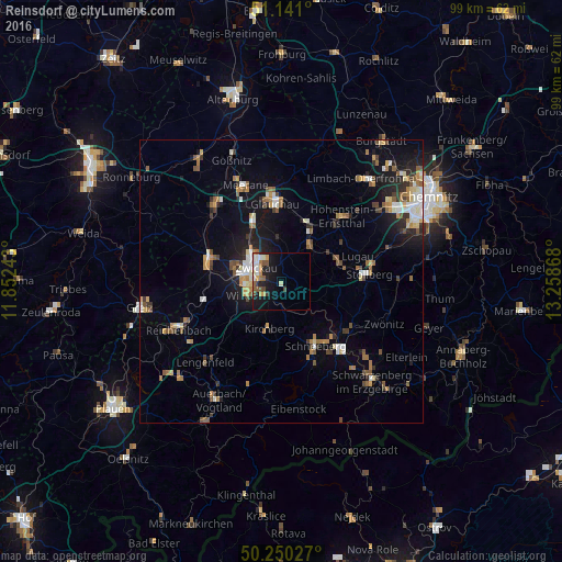
Analysis of Reinsdorf night lights 2016
Square area 10x10 km:
 2.81%
2.81%90-99
3.07%80-89
0.53%70-79
3.21%60-69
1.34%50-59
3.48%40-49
1.6%30-39
1.07%20-29
3.34%10-19
15.24%0-9
64.3%Square area 50x50 km:
0.93%90-99
1.24%80-89
0.82%70-79
1.06%60-69
1.17%50-59
1.48%40-49
0.87%30-39
0.95%20-29
1.58%10-19
5.69%0-9
84.22%Clear (daylight) street map image can be seen on geolist.org.
Map coordinates:
51° 8' 27.6" North, 11° 51' 8.7" East
50° 41' 51.9" North, 12° 33' 20" East
50° 15' 1" North, 13° 15' 31.2" East
Some cities around Reinsdorf sort by population:
• Zwickau
5.8 km =3.6 mi,  304°
304°
• Lichtenstein
8.4 km =5.2 mi,  38°
38°
• Mülsen
5.9 km =3.7 mi,  7°
7°
• Oelsnitz
10.7 km =6.6 mi,  73°
73°
• Wilkau-Haßlau
3.8 km =2.4 mi,  228°
228°
• Kirchberg
8.7 km =5.4 mi,  194°
194°
• Lichtentanne
9.2 km =5.7 mi,  266°
266°
• Hartenstein
9 km =5.6 mi,  116°
116°
2848725 (p: 8,907)
Sources (retrieved 2019-11-25):
» Earth at Night: Flat Maps 2012, 2016